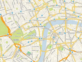
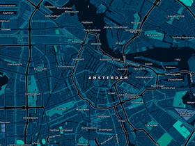
La informacion que aqui se suple es limitada. Es buena para marcar la casa de Juanito, o del get together de Mari. Basicamente para buscar carreteras. Sin embargo no es claro cuando quieres saber a que distrito electoral pertenece, si hay alcantarillado sanitario, si hay casas de empe/no o si la maldita B 28 pasa por enfrente de la tienda donde tengo que buscar los uniformes del nene.
Claramente hay mas informacion disponible, pero no esta disponible al publico general. Los mapas y la informacion de digamos cuadrangulos de USGS es sumamente anticuada, los mapas de carreteras cambian constantemente, asi como los nombres de calles y urbanizaciones.
Como entonces podemos empoderarnos y documentar la informacion para todo tipo de accion, desde denunciar crimenes ambientales, chotear puntos de droga o demarcar zonas maritimos terrestres? Una opcion es seguir el proyecto de Open Street Map.

Esta es la descripcion de su funcion y mision:
Open Street Map Project:
OpenStreetMap is a free editable map of the whole world. It is made by people
like you.
OpenStreetMap allows you to view, edit and use geographical data
in a collaborative way from anywhere on Earth.
O sea, que si yo abro su pagina, imprimo un mapa y le faxeo o envio via email una correccion en el mapa (digamos la Ave Patila era en realidad la Calle Nigua Resto) ellos lo editan en el mapa, que esta disponible a todo el mundo. Entonces esa informacion puede ser compartida por todos. Es el efecto de usar la masa de la web para cubrir un problema gigantesco para una sola persona (o agencia gubernamental). Esta opcion es de empoderamiento de informacion.
Para mas detalles de las posibilidades les incluyo una discusion de Michal Migurski, empleado de Stamen, una compa/nia de desarrollo y dise/no en San Francisco. Las posibilidades como todo proyecto abierto son inmensas...
http://mike.teczno.com/notes/nyc-return.html
My name is Michal Migurski. I
am the technology head at Stamen, a San
Francisco design and development studio focused on data visualization and map-making. You might remember me from such recent projects as Oakland Crimespotting, Walking Papers, Maps From Scratch, Digg Labs and API, Modest Maps, Mappr, or Reblog. Below, you will find my weblog, tecznotes, my link blog (high-frequency, short
posts), and with a collection of smaller and older things I've worked on.
From Michal Migurski's Teczone notes:
The social structure and set of motivations that OSM thrives under can be seen
as part of the broader trend towards shared development practices and better
communication enabled by the open internet. We're seeing a trend toward a larger
number of smaller operations unified by an ethos of participation and local
scale, something that Brian Marick has jokingly summarized as "artisinal retro-futurism" and "team-scale anarcho-syndicalism". I love this description.

UK designer Matt Jones of BERG used Cloudmade's style editor product to apply Kevin Lynch's ideas about the city as a network of paths, edges, districts, nodes, and landmarks for heavy traveler social network Dopplr. Particular ideas about the role of information on the map can be rapidly experimented with and published to a broad audience.

Stamen also did the Cloudmade Midnight Commander map style, answering a creative brief suggesting a design appropriate to Jason Bourne's in-car GPS. Again, something that starts as a small idea or even a joke can very quickly go into full production when simple, well-understood data is available.
Services such as Google's and the iPhone are bringing more different kinds of
people in close contact with cartographic design through their daily lives than
ever before. We know that use and familiarity breeds discerning taste, and
cartography has become popular, decorative, desirable, and functional.
I want to close with this napkin sketch by Mikel Maron. Many years ago, Mikel showed a possible "common operating procedure"around the project, incorporating numerous technologies not normally associated with desktop geography. Much of the methodology drawn here did not yet exist at the time, but Mikel could be sure that with healthy usage patterns it would be possible to draw double heads on each of the arrows with some reasonable expectation of future possibility.Ahora si que es verdad...me encantaria asi levantar un mapa de la red sanitaria de la AAA para asi marcar cada salidero sanitario de cada calle de la isla para enviar entonces como un layer de Google Earth o Google Maps (o en Open Street Map) para asi referirlo a EPA, la JCA, Recursos o al Departamento de Justicia. Esto tiene mas peso legal que treparse en el tope de un puente a causar tapones.
Tags en Blogalaxia

No comments:
Post a Comment